
agknow for QGIS
Plugin ID: 1584
Plugin for using the ag|knowledge REST API from geo|cledian
(25) votes
Download latest
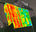
This plugin allows the usage of the remote sensing API ag|knowledge from geo|cledian.com. The API provides a field monitoring service that allows to monitor any agricultural field worldwide with a variety of vegetation indexes, crop parameters, times series analysis and comparison features based on satellite data.
Features of the plugin include the download and analysis of time series of visible and vegetation indexes rasters of registered fields. The data is based on Landsat-8 and Sentinel-2 currently. See https://docs.geocledian.com for a detailed product overview.
Please note that you will need a registered API key from geocledian.com to use this plugin for your area of interest. The plugin is delivered with a demo key that allows to access some demo parcels around the world for evaluation purposes.
| Version | QGIS >= | QGIS <= | Date | |||
|---|---|---|---|---|---|---|
| 0.7.5 | - | 3.4.0 | 3.99.0 | 13711 | jsommer | 2022-10-12T08:59:16.143805+00:00 |
| 0.7.3 | - | 3.4.0 | 3.99.0 | 193 | jsommer | 2022-10-11T10:54:10.571890+00:00 |
| 0.7.2 | - | 3.4.0 | 3.99.0 | 18202 | jsommer | 2019-01-10T14:13:20.952941+00:00 |
| 0.7.1 | - | 3.4.0 | 3.99.0 | 610 | jsommer | 2018-12-13T12:38:39.296171+00:00 |
| 0.7 | - | 3.4.0 | 3.99.0 | 665 | jsommer | 2018-12-11T19:27:30.981233+00:00 |


